Then … Scorpio takes over the wheel of the school bus, veering sharply from side to side on East Sir Francis Drake Boulevard in an attempt to dislodge Callahan. The railroad trestle from which Callahan jumped onto the bus crosses behind them near the highway flyover.
… and Now, the removal of the trestle (described in more detail in the previous post) cleared the way for the road to be widened and for the newer bicycle/pedestrian bridge seen here to be built. Mount Tamalpais punctuates the skyline in both images.
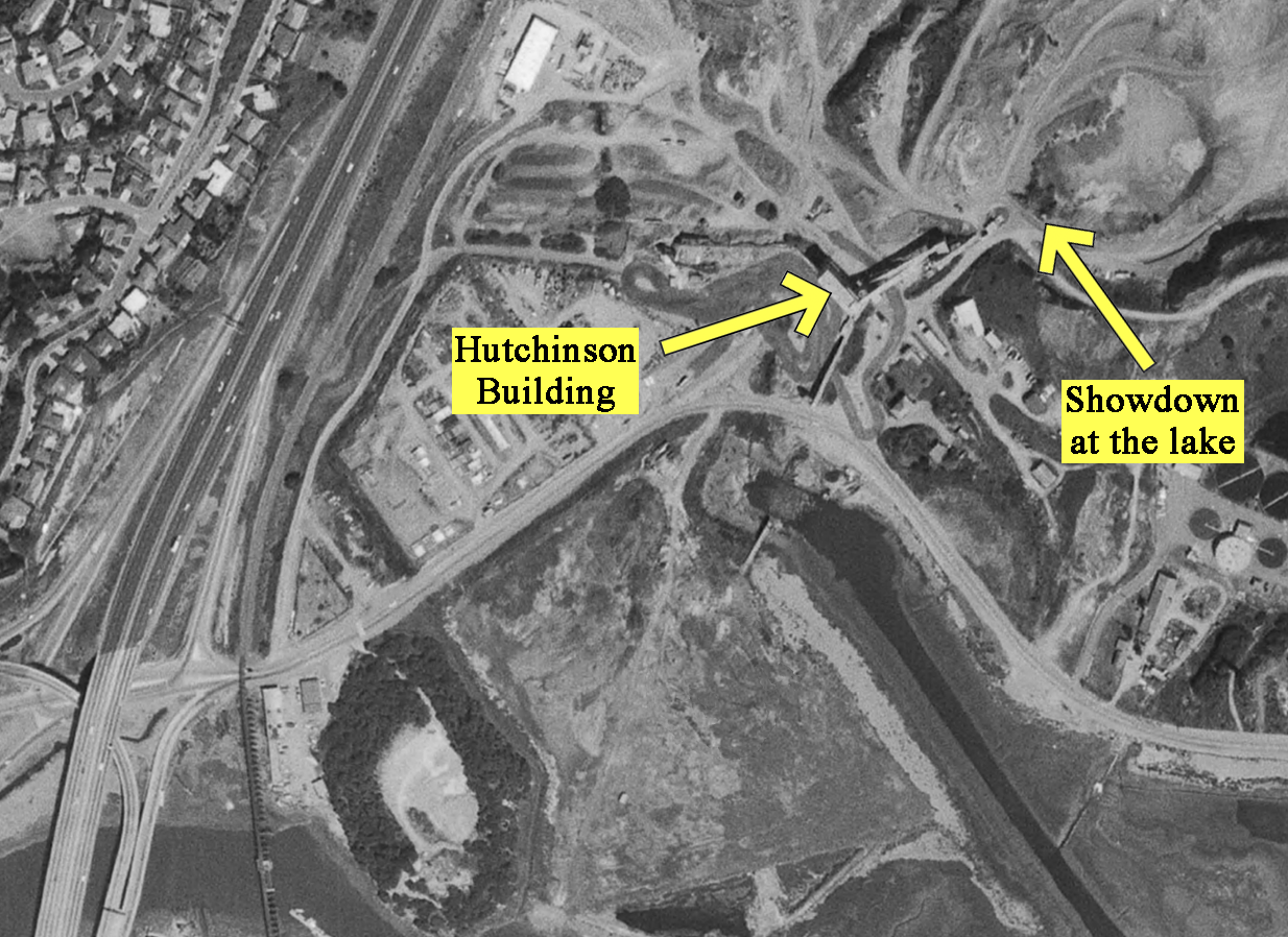
Then … Right ahead is Larkspur’s Hutchinson Co. crushed rock quarry. Callahan’s dangling head and gun drives Scorpio nuts; he continues the violent swerving. (Note the small cottage at far right - more on that in the next post).
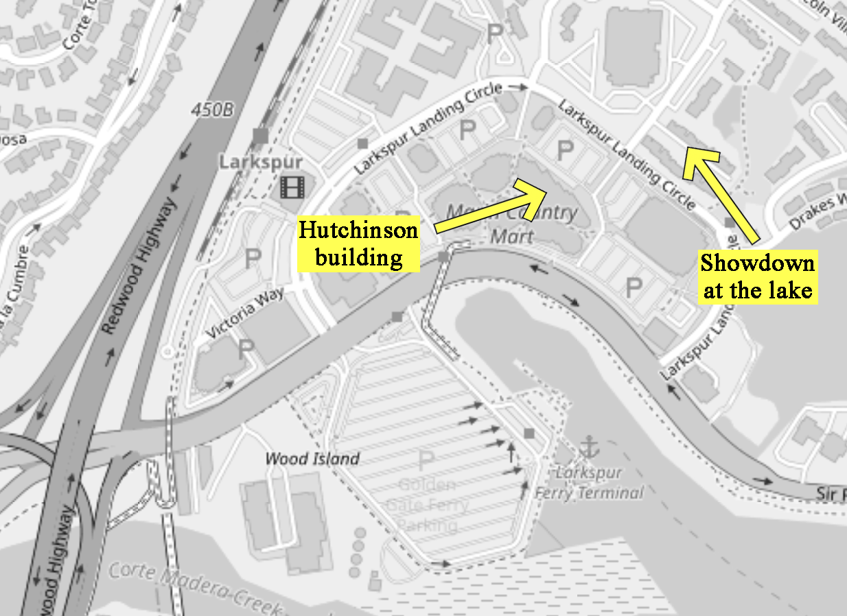
… and Now, the quarry site was cleared and redeveloped in the mid-to-late 1970s, becoming the Marin Country Mart shopping center, a hotel, offices, apartments and the Larkspur Landing Ferry Terminal. The matching view below on East Sir Francis Drake Boulevard looks towards the shopping center. Note the same electric pylon on the horizon in the center of both images.
The bus slides to a halt in a cloud of dust in front of the giant dilapidated Hutchinson building; Scorpio leaps out and runs off, pursued by Callahan.
… in 1972 … This photo of the building with its warped curvilinear roof was taken a year after Dirty Harry was filmed there.
… and Now, the red outline shows where that building used to be within today’s Marin Country Mart. For a frame of reference, the Farmer’s Market roadside banner in the foreground is the same one as in the ‘and Now’ aerial photo three images above.
The adversaries trade bullets during a hectic chase through the quarry buildings and conveyors.
When Scorpio spots a young boy fishing on a platform at the water-filled quarry pit out back he grabs him, maniacally screaming at Callahan to drop his gun. More than any other this frame captures the amazing job Andy Robinson did inhabiting the role. Rage personified.
Callahan faces Scorpio for the final showdown. He’s in a quandary … now what?
Then … He slowly lowers his gun, then … BANG!! … he lets fly a shot inches from the boy’s head, hitting Scorpio in the shoulder, allowing the boy to escape. What else would we expect from Dirty Harry?
… and Now, the Serenity At Larkspur (previously called Larkspur Shores) apartment complex covers this site today. Were Dirty Harry to fast forward on that same spot this is what he would see.
… and Now, the arrow shows where the final showdown took place. A small ornamental lake is the only reminder of the water-filled gravel pit that preceded it.
CitySleuth zeroed in on where the building and the showdown platform used to be by overlaying a 1968 aerial photo on a map of the area today. (Click or tap the image to toggle between them). (You can also clearly see the railroad trestle crossing East Sir Francis Drake Boulevard in the 1968 image, at bottom left).
When Scorpio reaches for his gun Callahan, for the second time in the movie, delivers his iconic ‘Well, do you, punk?...’ monologue. (The first time the punk didn’t feel lucky. He made the wrong decision).
This time the punk did feel lucky. He made the wrong decision.
Having finally got his man, Callahan calls it quits - he hurls his inspector’s badge into the water and walks away. As the end credits begin to roll a reverse view of the quarry complex shows Highway 101 in the background with the platform where Scorpio met his demise in the center foreground.
Then … The bus carrying Scorpio and the kidnapped schoolchildren is seen at top right driving west along John F. Kennedy Drive in Golden Gate Park past a small herd of bison, a species native to North America.
… and Now, this is the park’s 11-acre bison paddock; it’s been there since 1899 (map). The bison were introduced to the park in order to help save the species which at that time had been hunted close to extinction from an estimated 60 million in the wild when the European colonists first arrived. CitySleuth stopped by recently to take this matching photo from near the same spot.
Then … The bus next crosses the Golden Gate Bridge heading north to Marin County. The view looks back past the south tower towards San Francisco.
… and Now, from a macro perspective the bridge looks the same but a closer look below reveals added safety railings along the pedestrian walkways on either side and a center barrier that is moveable to accommodate the diurnal change in rush hour traffic flow.
Then … They are now in Marin County; the bridge is behind them as they climb the Waldo Grade on US highway 101 , about to enter the Waldo tunnel.
… and Now, a convenient little turnout area was the perfect spot for both the filmmakers’ and CitySleuth’s camera (map).
Then … The camera tracks the bus as it heads into the tunnel. The Waldo tunnel opened in 1937 as a single-bore (the one on the left); the second bore, completed in 1954, enabled one-way traffic in each direction. The archways were rainbow-painted in 1970, prompting an alternative name: Rainbow Tunnel.
… and Now, the tunnel was renamed in 2016 in memory of beloved Marin County comedian and actor Robin Williams following his tragic suicide.
… in 1947 … on a trivia note, here’s Lauren Bacall driving her Woodie wagon out of the original two-way bore in one of CitySleuth’s favorite SF movies: Dark Passage.
Then … Scorpio orders the bus driver to take the Sir Francis Drake Blvd Larkspur exit. The exit sign is outside the Larkspur city limit, marked by the next sign just ahead.
… and Now, what appears to be the same sign is still there but it’s now inside today’s city limit sign. One or both have been moved from where they were when the movie was filmed. A comparison of the background hills Then and Now reflects California’s seasonal brown/green change.
Then … As the bus exits, Scorpio’s jaw drops; he spots Callahan standing on a railroad trestle spanning Sir Francis Drake Blvd at the highway exit.
Boy, that Eastwood pose on the trestle sure looks familiar - remember him 6 years earlier in The Good, The Bad and the Ugly? Don’t mess with these guys, O.K.?
… and Now, the trestle, built in 1884 by the Northwest Pacific Railroad, is no longer there - it was removed in 2003 after being damaged by a passing tractor-trailer. More recently (2015) a bicycle/pedestrian bridge has been built alongside where the trestle used to be (the arrow points to extant trestle remains).
Then … Callahan gets set as the bus approaches …
… and Now, viewed from the same vantage point there’s now an unobstructed view of the 101 highway flyovers in the absence of the trestle bridge.
When he makes a daring leap onto the roof of the passing bus we fear for the schoolchildren, realizing the showdown must come…
Then … Callahan rushes over to the location where Scorpio revealed Ann Mary Deacon was buried. He watches as a medical team, just visible in white coats at the bottom of the image, opens an undergound vault.
… and Now, this matching view was filmed at Battery Spencer off Conzelman Road in the Marin Headlands (map), a popular tourist spot today because of its spectacular view of the Golden Gate Bridge reaching over to San Francisco. Above, Callahan was looking down from the battery to a small promontory where the victim was found, marked by the arrow below.
Here’s a wider aerial view showing where the arrowed promontory is relative to the battery complex.
Battery Spencer, armed with three M1888 12 inch guns was part of the Harbor Defense of San Francisco from 1897 until 1942 when it was deactivated. Here’s one of the guns in a c. 1913 image. Never fired in anger, only in practice. The guns were mounted on the three circular bases, still there and visible in the image above.
The young teenager is lifted out; she had been raped and murdered by Scorpio even before he came up with the lie that she had been buried alive with a limited oxygen supply. Callahan’s prediction from the start was chillingly right on (“You know she’s dead don’t you”, he had said).
It’s the morning of George’s execution; word of the murders of Susan and Henry in Paris that same day have not reached California as he is being prepared for the gas chamber. In these remarkable images filmed inside San Quentin the guards attending him were the real guards, not actors.
He is led into the gas chamber where a guard stands ready to strap him into one of the two side-by-side chairs.
The chamber door is closed tight and the guard, poised to turn on the gas, watches the clock as the final minutes tick down to the 10 am execution time.
We learn of George’s fate from a TV reporter and the telex message that brought the news of the shocking events in Paris to the Californian authorities just minutes before execution time. (Typo trivia note - the name ‘Worsmer’ should be ‘Wormser’).
Then … Speaking from within the gas chamber, viewed from outside through an open door, the reporter explains that the telephone next to the chamber with a direct connection to the Governor’s office rang just before the deadline with a reprieve order. George’s life had been spared and he was released.
… and Now, here’s that same door in a March 2019 photo, now closed and referencing Executive Order N-09-19 which reprieved all prisoners on death row at that time from execution and banned further capital punishment during the term of the current Governor. This after the State had spent $5 billion on a death penalty system that had executed only 13 people since 1978.
Then … The movie ends with an overhead shot of San Quentin Prison. The panorama below captures the entrance area of the prison at lower right and on the left looks east across the Richmond-San Rafael bridge towards Contra Costa County in the distance.
… and Now, here’s a recent aerial view of the prison and of the bridge, the northernmost east-west road crossing of San Francisco Bay (map). Both are still there and operational.